
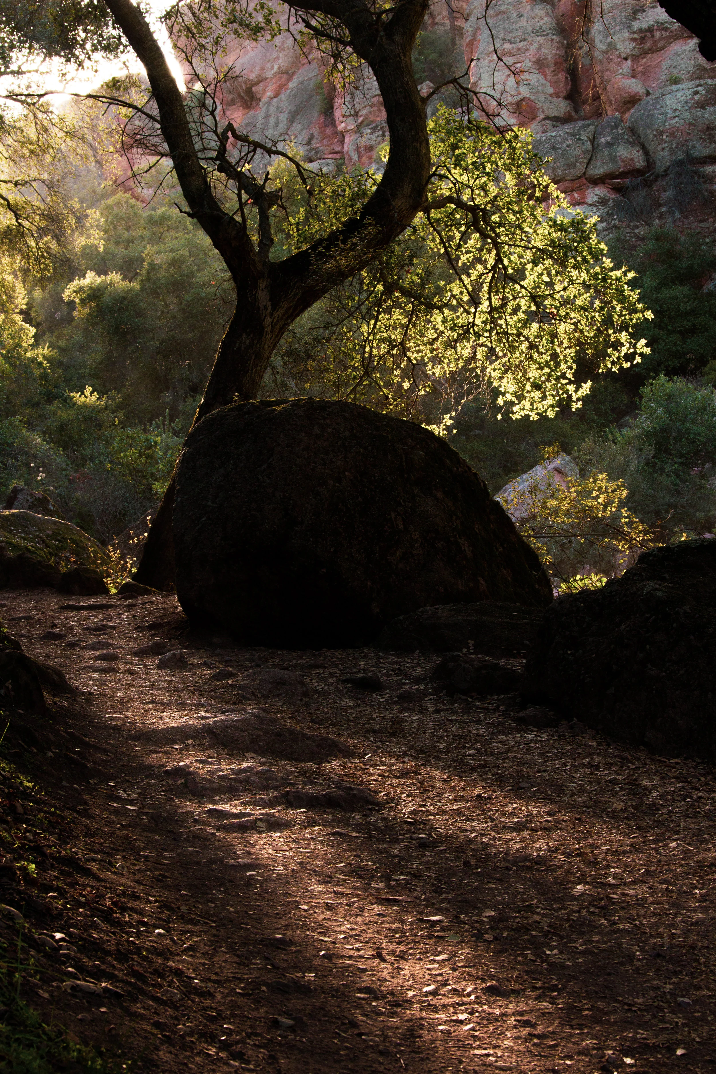
The sun finally pokes through the clouds during sunset. Bear Gulch, Pinnacles National Park.
From the towering granite walls of Yosemite Valley to the extreme heat and surreal wonder of Death Valley, the beauty and diversity of landscapes in California is unparalleled (at least in the contiguous 48 states). California is well renowned for its geography; the redwood forest, Joshua Tree, and Big Sur top the list for many. However, often overlooked and longing for attention, Pinnacles National Park has the benefit of being both extremely accessible and also full of adventure.
I recently visited Pinnacles National Park and had arguably one of my favorite experiences in a national park! It’s very doable for a day or half-day long excursion, there’s all sorts of hiking to do and wildlife to see. Bonus: it’s gorgeous!
Sun Rays, Pinnacles.
Established as a national park in 2013 by then-President Obama, Teddy Roosevelt originally ordained Pinnacles National Park as a national monument in 1908. The park gets its name from the pinnacle-shaped rock formations throughout the park, somewhat similar in appearance to the hoodoos of Utah. These pinnacles formed from an ancient volcano that has eroded with time. Fun fact: the volcano was originally located some 200 miles away, but shifting plates pushed the remains of the volcano to its current location (science!). The pinnacles themselves rise out of the earth as strange bulbous shapes, often vertical walls ideal for climbers.
Splitting the park into two, the mountainous Pinnacles divide the park into two halves, east and west, with no road connecting them. The east side is the most popular, and the rest of this post will primarily focus on the eastern half. Located just two hours from San Francisco, the eastern entrance to the park is easily accessible for a weekend getaway for any northern Californians.
Despite being made a national park in 2013, no one designed Pinnacles (as if people can truly design a natural wonder) to be a national park. Pinnacles is a fantastic little park, but it’s a little park. Excluding the untamed, wilderness portions of the park (most of it), you could hike the perimeter of the park, around 11 to 12 miles, in a day. Personally, I found this to be a fantastic change of pace; most national parks involve a lot of driving to see the park. With Pinnacles, you can park your car in the morning, hike all day, and see the majority of the park.
That being said, the small size of the park coupled with the fact that it’s a relatively recent addition to the ranks of national park do result in some issues for visitors. For one, there's almost no parking in Pinnacles; get there early. When I went in February (shoulder season), parking for Pinnacles’ most popular area, Bear Gulch, filled before 10 am. Fortunately, the park does operate a shuttle between trailheads and the parking lot near the visitor center. The other downside is that the facilities in the park aren’t nearly as developed as other national parks. Thus, while there are restrooms throughout the park, they're small and can create large lines. Similarly, the visitor center won’t be as modern as some you’ll find in older national parks. However, these downsides are negligible and the adventures one can have at Pinnacles well make up for its minor inconveniences.
WHAT TO DO AT PINNACLES

What to do at Pinnacles: Hike and drink beers with your bros, of course.
Even though Pinnacles might be diminutive in size (it’s the 5th smallest park), it boasts a broad range of outdoor offerings. First and foremost, Pinnacles maintains an array of hiking trails, ranging from relatively easy 2 mile out-and-backs (Bear Gulch Trail) to longer, more involved hikes (Chalone Peak Trail). Secondly, the park offers an ideal environment for climbers— the towers of rock extending out of the earth make for a great way to show off your climbing skills or test your fear of heights. On a windy day in February, I saw climbers dotting most any pinnacle of notable size; the fact that the face of the rocks have course grooves (I’m sure there’s a more technical climbing term) seemed to me to be ideal for finding small handholds. Thirdly, the amount of birds and potential bird watching in the park amazed me. Almost every national park boasts hundreds of species of birds in their park (birds are ubiquitous), but in Pinnacles not only were the birds everywhere, but they were extremely varied in terms of species. In fact, for anybody truly interested in bird watching, the return of the California Condor to Pinnacles has been nothing short of a success— it’s now quite easy to spot them soaring through the air, often in the higher altitude parts of the park.

Pinnacles has phenomenal bird watching.
If you only have a day at Pinnacles, I’d highly recommend hiking the Bear Gulch trail and connecting it to the High Peaks trail. You can hike through caves, past massive reservoirs, and scale cliff faces using depression-era footholds. The hike starts at the Bear Gulch trail-head near the Bear Gulch Day Use Area. To get there, continue on the east entrance road, passing the visitors center on your left. Follow signs towards Beach Gulch, making a left when the road forks. Follow that road until it dead-ends at the start of the Bear Gulch trail. Please note: parking fills up extremely fast, so get there early in the morning to park your car (i.e. before 9 AM). Once you get to the Bear Gulch parking lot you’ll see some restrooms and a drinking fountain near the start of the High Peaks trail. This confused me momentarily, the start of the Bear Gulch trail is NOT by the parking lot restrooms. Instead, if the restrooms are on your right, follow the sidewalk out of the parking lot (heading south-southwest), past some picnic benches and grills, to the start of the Bear Gulch Trail.
There are essentially two choices from here: go through a really cool cave or don’t. You can take the Moses Spring Trail to the Bear Gulch Reservoir, which avoids the cave, or you can hike and meander through the Bear Gulch Cave. I’d recommend going through the cave, even if you don’t really enjoy caves. If you do go through the cave, bring a flashlight/headlamp. iPhone flashlight should work okay too. Also, if you’re a taller person like myself, watch your head. There are a number of low hanging sections that require some bending and squatting, but they’re manageable. The cave itself formed from massive rocks breaking off and getting stuck between pinnacles. Thus, the cave is more open than a true “hole-in-the-ground-type” cave.

Wildlife along the Bear Gulch Trail can sometimes get a little too personal.
After deciding to venture through the cave (because it’s really cool, of course), you’ll find yourself at Bear Gulch Reservoir, a great place for a picnic. Please note: the squirrels here seem to have no fear of humans and will follow you if you have food. This is also the spot I saw a fox and numerous birds. If you enjoy wildlife, hangout at the reservoir for an hour or so and watch all the animals that stop by. If you’re going to continue to the High Peaks trails (highly recommended), you’ll want to make a sharp right immediately upon reaching the reservoir and get on the Rim Trail. This then gains elevation and curls around towards the way you came through the caves. Note: this part isn’t very clearly marked with signs so you may want to reference a map when hiking. You may pass some climbers on the rim trail until, about half a mile down the path, you reach the High Peaks trail.

A view of the moon from the High Peaks Trail
The High Peaks trail is phenomenal— it takes you past and through some of the highest and largest pinnacles in the park, and offers fantastic vistas. It does require a bit of patience and nerve when traversing the steep and narrow section, but fear not, almost anyone can hike the High Peaks trail. At the junction from the Rim Trail you’ll want to go left to continue to the High Peaks trail. The High Peaks trail takes you to one of the highest points in the park, requires navigating footholds drilled into the rock by the Civilian Conservation Corps in the '30s, and offers great chances to see the California Condors. You’ll follow the High Peaks trails until it meets the Bench Trail, which you can connect back to the Bear Gulch Trail.
The most exhilarating section of the High Peaks trail is the steep and narrow section. You’ll see it mentioned and photographed numerous times on the park website and on park brochures. The steep and narrow section refers to a small part of the High Peaks trail that’s situated on the edge of a cliff. Fortunately, there are footholds and a safety rail throughout the most treacherous parts of the trail. I would say that as long as you were capable of hiking up to the steep and narrow section, then you should have little to no issue with this part of the hike.

My girlfriend blocking the steep and narrow section like an inconsiderate hiker!
The most dangerous part of the steep and narrow trail isn’t the trail itself, it’s trying to navigate the somewhat tricky and often very narrow trail with other people trying to hike the other way. Patience is key here. Fortunately, there are a number of sections on the steep and narrow part of the trail where you can pull off and relax; this makes both an ideal place to have a snack and watch for Condors. Likewise, this part of the trail offers a magnificent panoramic view of the surrounding mountains. If you’re trying to photograph the mountains, most of your views will be easterly (the high peak pinnacles block most of the view to the west). This lends itself to sunset photography (if you want the sun at your back), however, this also requires hiking in the dark after the sun goes down.
After the steep and narrow section, the trail is very well marked; for a shorter hike you can turn off on Condor Gulch Trail and that will take you back near the Bear Gulch parking lot, or you can continue on the High Peaks trail, connecting back to the Bear Gulch trail via the Bench Trail. The longer route takes approximately 5 hours start to finish if you stop to take a lot of photos like I did.
One side note for any bird photographers: if you’re after Condors, you’re going to have to take the High Peaks trail (or one of the other higher altitude trails in the park) up to where the Condors like to hangout. However, if you enjoy any kind of bird, I found that the area near the Bear Gulch parking lot offered fantastic bird watching. Not only were there a number of woodpeckers, but I also saw X species, Y species, and Z species all flying about. Great place to add to your eBird.
RECOMMENDATIONS AND CONSIDERATIONS BEFORE VISITING
- Hike through Bear Gulch Cave or Balconies Cave.
- Bring sunscreen and lots of water, it can get extremely hot here.
- If you’re planning on doing a longer, multi-hour hike, bring something to snack on.
- Get to the park early in the morning: bird watching will be better, lighting will be better, and you’ll actually be able to park.
- If you hike in the shoulder season (e.g. February) the weather can be quite volatile: extremely hot in the low, un-shaded parts, and windy and cool up in the High Peaks. Thus, wear a number of breathable layers.
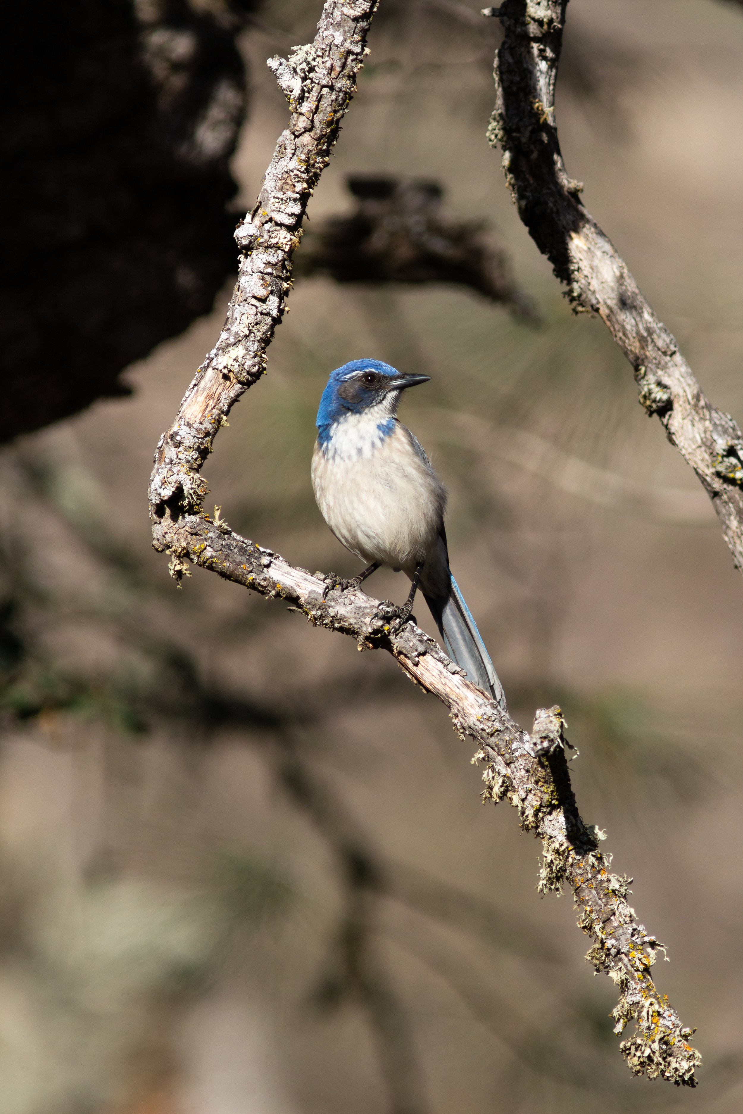
Some kind of blue bird along the Bear Gulch Trail.